2007年VOA标准英语-Holocaust Museum, Google Map Out Crisis in Darf(在线收听)
Washington
10 April 2007
The U.S. Holocaust Museum has launched a joint project with Google's satellite imagery Web site Google Earth to promote awareness of the crisis in Darfur and give the public a new perspective on the death, displacement and destruction that is going on there. VOA's William Ide reports from Washington.
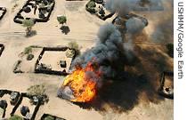 |
| Burned Darfur village as seen on Google Earth |
"Google Earth allows us to see something that could have gone on unseen," said Lawrence Swiader. "This technology allows us to visualize something in seconds and minutes that otherwise might take pages of text and columns of figures to understand. If ever."
Over the past four years, Darfur has been torn by fighting between government-backed militias and rebel forces that have left more than 200,000 people dead and displaced more than two million others.
Swiader explains that the new addition to the Google Earth website allows visitors not only to hover over massive fields of refugee camps and begin to grapple with the sheer numbers of the displaced, but to also see the destruction they left behind.
"You're going to see these structures, you'll see them and they will be represented by hollowed blackened circles on the ground," he said.
The high-resolution images of the "Crisis in Darfur" project allow users to zoom in on the western portion of Sudan, where Darfur is located, an area about the size of the southern U.S. state of Texas. Users can view more than 1,600 damaged villages and 100,000 homes, schools, mosques, and other structures destroyed by militias.
Google Earth's vice president of Global Communications, Elliot Schrage, says he hopes the Website will not only spread understanding, but spur countries to take action.
"The marriage of satellite imagery, 3-D mapping technology and search makes geographic information easily accessible, understandable and useful, empowering organizations like the museum to communicate, to educate and importantly to advocate in order to improve our world," said Elliot Schrage.
Daowd Salih, a native of Darfur, former aid worker who has helped focus world attention on the crisis, voiced his hope that the project would put Sudan's President Omar al-Bashir under increased scrutiny.
"We need people to understand what is happening," said Daowd Salih. "We need President Bashir and other perpetrators to understand that they are being watched."
Holocaust Museum Director Sara Bloomfield said she hopes this new initiative will make it much harder for the world to ignore Darfur, but acknowledges the challenges as well.
"We have found sadly that even with a lot of visual information about genocide, and I am talking about post-holocaust genocide that the difference has been somewhat, but not what we would have hoped when the world said never again in 1945."